Had to stop and take a closer look at this beautiful old brick silo, still standing on an abandoned farm…


Photos above:
Fuji Velvia 35mm film


Had to stop and take a closer look at this beautiful old brick silo, still standing on an abandoned farm…
Photos above:
Fuji Velvia 35mm film

That didn’t take long. Today’s post includes the last few photographs I have to share from my recent excursion through eastern Canada. This trip generated far fewer images than past adventures of similar distance or duration. There’s a reason for that…

On most road trips, I’m winding my way across the wide-open prairies, deserts, badlands and high country of the American West. Roaming under the Big Sky is, photographically, very stimulating; each turn of the road or the trail presents a new look at the marriage of land and sky. I return from every western journey with hundreds of photos.
Driving or hiking through heavily forested regions is different; though still quite satisfying, it’s more of a relaxing, contemplative experience rather than a photo opportunity. When I’m immersed in the forest, I don’t reach for the camera nearly as often.

Am I anti-tree? Certainly not. I greatly enjoy hiking in the woods during fall and winter, as well as taking long drives through Canada’s vast boreal forest. However, to me, nothing is more enjoyable than watching the sky. When I’m boxed in by a multitude of trees (or hills or mountains, for that matter), I’m missing out on sunrises, sunsets, moonrises, moonsets, interesting clouds, soaring birds, approaching storms, the beautiful colors of twilight. Having an unobstructed view of the horizon is something that I treasure. My preference is to appreciate trees in smaller doses—a stand of aspens marking the path of a stream that snakes across a broad Colorado valley, for example. A solitary tree standing guard on the prairie is one of my favorite sights; on many occasions, I have visited this lonely old cottonwood that lives on a South Dakota ranch…

I find that spending time with a single tree, or with a small grove, is more rewarding than a journey among countless thousands of trees. Even so, the larger forests do have their charms, and I’ll keep on driving through the wilds of Canada, hiking in silent woods carpeted with freshly fallen snow, and visiting all of my favorite trees. As for day-to-day living, I hope to be doing that on the Great Plains someday…preferably, on a piece of land that has one tree within hiking distance.


This autumn’s long road trip gave me my first look at Quebec and The Maritimes; I made it as far east as Port Morien, Nova Scotia. I was asked by a few people if I would be continuing on to explore Newfoundland & Labrador. No, my first visit to that province will be a monster of a trip all its own. At some point in the next few years, I’ll embark on what will likely be the Pontiac’s greatest challenge: driving the Trans-Labrador Highway—probably the most remote and loneliest highway in all of North America. Should I reach the Labrador coast, I’ll be far closer to Greenland than to New York City.
To this day, Labrador remains a vast boreal wilderness with very few inhabitants; only 27,000 or so live there, mainly along the coast. It is a land of rugged terrain, dense brush, fierce weather and legions of biting insects. Life is hard there, even for the Indigenous Peoples of the region. Few visitors see Labrador’s interior.
Imagine traversing this daunting landscape in 1905, with no map to guide you…

Warning: This report contains spoilers…
Leonidas Hubbard, Junior set out in 1903 to chart a course through the harsh interior of Labrador—said to be the least-explored region of North America at that time. His party became lost in a labyrinth of lakes and swamps, and the cold air and snow arrived early that summer. They were unable to secure sufficient game to feed themselves as their supplies dwindled. Too weak to travel, Leonidas died from starvation, alone in his tent, after his two companions had raced off separately to bring back food and a rescue party.
Mina Hubbard, now a 33-year-old widow, grew determined to complete her husband’s journey. She was an absolute novice regarding this type of travel, and most people were shocked at the idea of a woman participating in an exploratory expedition, let alone leading one. But she planned it well, teaching herself navigation and mapping skills, researching equipment and provisions, talking with trappers and sportsmen who knew the territory, and assembling a reliable crew: Joseph, Job, and Gilbert; the fourth man, and the greatest asset to the team, was George Elson, a survivor of her husband’s expedition.
In late June of ’05, they loaded two 19′ canoes with their gear, which included plenty of flour, rice, coffee and other staples; meat, fish and berries would be procured as they traveled. Leaving the Northwest River trading post, the expedition began its long slog up the Nascaupee River, struggling against the swift current and making several portages along the way.
They finally came to the sprawling Lake Michikamau, and shortly thereafter, to the river’s source, which Mina named Lake Adelaide (zooming out from this aerial view will give you an appreciation for the ruggedness and isolation that this wilderness offers). Crossing over the height of land (the present-day boundary between Labrador and Quebec), the team descended the George River. They soon found themselves in the midst of the largest caribou herd in the world—hundreds of thousands of beasts in migration mode. Farther on, the expedition passed through the great Barren Ground of northern Labrador, and in late August, arrived at the Ungava Bay trading post, where they waited for the final southbound ship of the season—Hudson’s Bay Company’s steamer, Pelican—to return them to Rigolette.
All told, they canoed and portaged 576 miles from post to post during those 62 days in the summer of 1905, and gave us the first accurate mapping of the Nascaupee and George Rivers.
Mrs. Hubbard’s book is not a cold play-by-play of each day’s progress, but is written in a storytelling fashion that allows her to expand upon many aspects of the adventure. She writes of their successes and discoveries, their worries and critical decisions, their near disasters. She describes their friendly encounters with the Montagnais and Nascaupee tribes of the interior. She writes of animal behavior, thoughts of home, thoughts of her late husband, the personalities of her companions, their moments of joy along the way, and her appreciation for the beauty of her surroundings.
The men were very protective of Mina and constantly worried for her safety; to their dismay, she had an adventurous streak and loved wandering off alone to hike up hills and mountains, smiling and happy as she walked along. In addition to her revolver and hunting knife, Mina armed herself with one Panoram Kodak Camera and one 3.25″ x 4.25″ Folding Pocket Kodak Camera…


I discovered A Woman’s Way Through Unknown Labrador by a reference in another book on northern exploration (although the title of that book escapes me). I learned enough about Mina Hubbard’s expedition to know that I definitely wanted to acquire a copy of her book, and I was lucky to find this 1908 first Canadian edition. This particular book was the obvious choice for a cartophile like me, as it came complete with its original color copy of Mina’s map, detailing the routes of the two expeditions. The map is stored in a pocket within the back board, and is in remarkably good condition for its age…

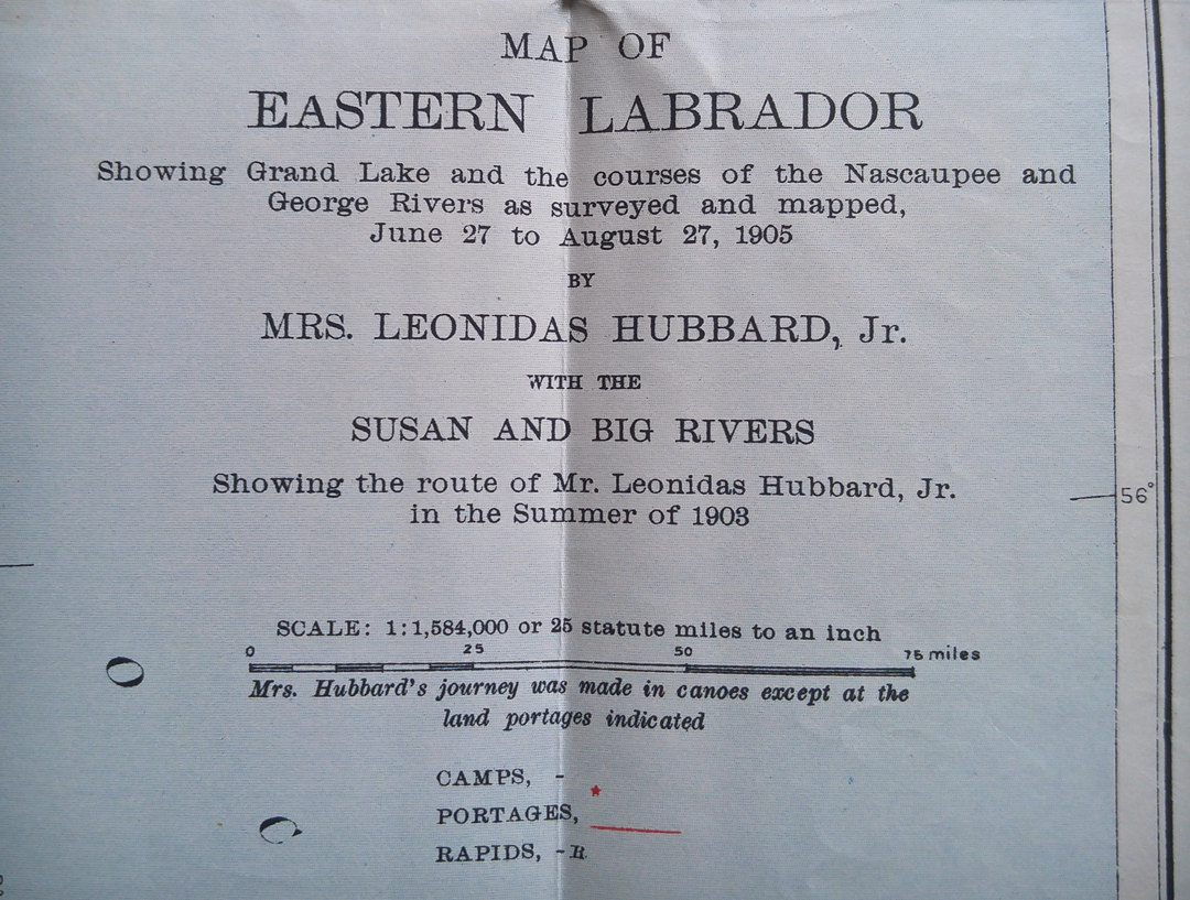

Mrs. Hubbard’s map became the benchmark for this region, as recognized by American and European geographical authorities. Several of the lakes and land features along the route still bear the names that Mina affixed to them in 1905.
Included in this book is the diary that Leonidas Hubbard kept during his expedition, along with George Elson’s account of those final days, his harrowing solo journey to find help, and his return the following spring to retrieve Mr. Hubbard’s body.
I don’t purchase books as investments; I buy them to read, and I look for sensibly-priced copies. Yet, for whatever reason, I felt that I needed a premium edition of this title, and it is indeed the most money I’ve ever spent on a single book. Even so, no regrets here…it is a beautiful book and a great reading experience.


Photographs, map and text: Copyright 1908 by Mrs. Leonidas Hubbard, Jr. (Mina Benson Hubbard).
(Posts about my library are archived through this link: ridingwithcarl.wordpress.com/tag/library.)

When I left my tent for a morning hike, little did I know that I would find myself in a wilderness rock garden, featuring colorful plants and beautiful pools of cool, clear water. Such was my luck when I chose to camp on the shore of James Bay at Longue Pointe, north of Chisasibi, Quebec.
Just before the hike, I listened to the birds and watched the sunrise from my seaside campsite…

Hear the birds and the waves for yourself by watching this brief video, recorded at the above location: YouTube Vimeo
Leaving the shore and walking uphill through the trees and brush, I arrived on the high ground of Longue Pointe—the exposed gneissic granite of the Canadian Shield…

The pools are perennial fixtures of the terrain, fed only by rain and snow…

Here’s another short video, which will give you a 360° tour of this area: YouTube Vimeo


Fascinating microecosystems…


Algae? Pollen? Ribbons of orange floating on the still water…

I never thought it was such a bad little tree: Below, a ragged little evergreen makes its home on the hard stone…

I left the trees behind as I walked westward toward the end of the point…

Above and below, dikes of pegmatite run for long distances across the great slabs of granite…

Terminus: The western tip of Longue Pointe, where the rock dives below the calm, blue waters of James Bay…

A short but extremely satisfying hike…one that I’d like to take morning after morning. Perhaps I’ll be able to stay for several nights on my next visit.
